In this thread I will talk about a huge abandoned railway network very near to where I used to live:  The Trafford Park Railway.

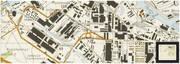
Trafford Park is a huge industrial estate in Manchester in the North West of the UK. It had a railway network, which was part of the gigantic railway network called the Manchester Ship Canal Railway.
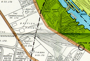
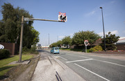
In my opinion, the Trafford Park Railway was a railway like no other. The rails went extremely close to the road, and crossed it many times, calling for some really unique level crossings, such as the Trafford Park Road/Moorings road Level crossing (seen below), which had a total of 9 wigwag lights (one of them was an extremely rare overhead one)!

 
(none of these images are mine)

This railway was used extensively in in the early to mid 20th century. After which, usage went down. The railway shut down completely in 1998 as road transport was replacing rail freight. Here are 2 good videos about this railway  https://www.youtube.com/watch?v=59As5lq8hC8  and https://www.youtube.com/watch?v=1HNwrzB9O4E. If you ever drive through trafford park, it is a strange sight to see level crossings in the middle of a road, despite no rails anywhere!

A wikipedia article about this https://en.wikipedia.org/wiki/Trafford_Park_Railway


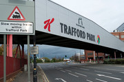
These signs are still there to this day!

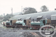
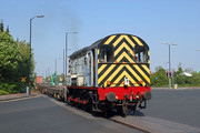
Although the railway closed, a branch line running alongside Barton dock road and past the kellogs factory remained operated by class 08 and class 09 shunters pulling containers between Manchester international Freight terminal and Barton dock freight terminal. This 2 kilometer stretch of line was the last part of this giant rail network. It finally shut down around about late 2012.
Me and my family often went down barton dock road when we needed to go shopping in Asda or the Trafford Centre. Although I don't recall seeing the train itself, I do remember seeing the line when it was still serviceable, and watching it deteriorate over time: a truly sad sight to see.


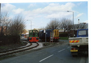
 08445 crossing Barton dock road 12/04/11

So this was me blabbering on about a closed rail network that fascinates me: a rail network that is a reminder of how industries worked many decades ago.

A very neat place and story GG-Fan I see the problem here...you all are driving on the wrong side of the road 

25 days later

I am currently mapping out the entire railway (most of it at least) on google earth. I will post an image of the entire railway soon, although I think it may need it's own thread.

It would be fine in this Thread GG-Fan. We can always re-title it.

Looking forward to seeing your map.

That'll be good, since there doesn't seem to be a good map online. I wonder if you've seen this?

Loved that little short video, thanks GG-Fan. I like how they used comparison photos from the past with Google maps.  Wonder what had happened to the Steam Engine used on that line after 1974?

@[deleted], It was restored https://www.youtube.com/watch?v=mG3rE5UhFg8

About my trafford park railway map: On this 1963 map of trafford park  https://www.flickr.com/photos/36844288@N00/48020024848/in/faves-50559291@N03/, you can see the railway has tons of branches that are impossile to locate on google earth. What I mean by that is that no matter how far I go back on google earth, there is no sign of any remaining rails, or any other infrastructure, so on my map you will only see the ralis that closed in 1998 or shortly prior (except the barton dock branch)

Thanks GG-Fan
They did a wonderful restoration on her but I wonder why she wasn't restored in her original livery which brings to my mind this question. Was this engine the only engine ever on this Paper Mill Line and did she spend her entire life there?

I believe there were more steam engines at the mill thanks to this picture.


As it happens, I live very close to the remnants of this railway, though not much remains, only a crossing a few other bits still stand

You also lived in Manchester? Wow
Do you ever remember seeing the train at barton dock road?

@GGF I still live around the Manchester area, though I don't remember seeing any locomotives at this railway, I only really remember just seeing what's left

This is a really cool project you’ve undertaken. Industrial railroads are kind of the unsung heroes of transportation. Possibly going so far as to say unappreciated or even maligned.

Here in the US, there’s often a push to turn disused rail lines into hiking trails. I guess that with the numerous level crossing and the line running through (active?) industrial areas, that’s less attractive to local councils or agencies.

This is really Neat Super unique can't wait to see the map when its complete gg-fan

A problem I have is that a lot of lines are obliterated. Such as here :


Maybe in the fullness of time your map could have faint or dotted lines for track sections that have now been obliterated?